The Canary Islands are synonymous with beach holidays and easy living. With a few tame resorts on the coastline, Gran Canaria is no exception. Go inland a few miles, however, and the landscape is transformed into a greener (but smaller) version of the Grand Canyon. Trans Gran Canaria is a 125 km race predominantly through and over this mountainous interior with about 7500m of climbing in no more than 30 hours. My participation was dedicated to our Reed Exhibitions colleague Sukhi Dhariwal who tragically lost his life before Christmas and our fundraising is to support the future education of Sukhi’s young daughter, Ronja. For the quick version of events, see the video below but for the full gory details read on. (Featured image credit: Andreas Øverland)
Stage 1: Playa De Las Canteras to Arucas (16.5km, 730m+)
From the finish line in Maspalomas where most people were based, we took a 45 minute bus ride to the capital Las Palmas where a festival had sprung up around the start line on the beach at Playa de Las Canteras.

Among the 886 starters, I picked a spot about two thirds of the way back from the elite folks and set off at 11 pm along the beach for the first couple of miles. As usual in these events, there were big crowds cheering us on and a lot of pointless jockeying for position given that we’d be on our feet for many hours to come and would be more or less alone in the later stretches.
My plan was to hammer the climbs and to moderately attack the downhills. I’ve done a few mountain ultras by now and felt confident enough I could finish it even if I overcooked the first half. It was therefore a relief to leave the (dull) flat bit behind and to get stuck into some lumps on the way out of town. The conditions under foot for the first 10 miles were beautiful: lots of hard-packed earthen trails and even the occasional stretch of smooth asphalt so I gently upped the pace as we weaved through a series of small villages. After a while we dipped suddenly into a steep-sided valley and I was introduced to what would turn out to be the default terrain for the race: wobbly, jagged rocks (and lots of them). The first aid station, at Arucas, was on top of a steep but relatively short climb and was jam-packed with runners. Without needing any food I just topped up my water and pushed on.
Stage 2: Arucas to Teror (27.1 km, 1360m+)
I don’t remember much from this section other than settling into a rhythm on the climbs that were getting progressively longer and steeper. Also, there were a dwindling number of supporters as we pushed into the wee small hours. On arrival, the refreshment zone in the aptly-named town of Teror was actually a delightful arrangement with lots of helpful volunteers. The only problem, however, with my new Inov8 Race Ultra 10 pack (which I generally love) was refilling the bottles. What was rather fiddly to extract in the early phases turned into a kind of delinquent fire hydrant by the end as I progressively lost most of my coordination faculties. Anyway, a big gracias to the volunteer dressed like Asterix who managed to fill both of my bottles in under 1 minute.
Stage 3: Teror to Moya-Fontanales (38.8km, 2406m+)
The route out of Teror took us straight past the boozed-up smokers that were milling around outside the local nightclub. In a surreal collision of worlds and eyeing each other with trepidation, we thawed into a friendly exchange in which I cobbled some sort of Spanglish response to their encouragement along the lines of: I’d rather be with you having a drink right now. That was a lie, though: I was having a ball and pushed through the next section with relative ease. Arriving at Moya-Fontanales, I was really pleased with the pace I was holding but I started to see the first runners hunched under blankets in a sort of zombie state – having pushed it too hard too early, got a stomach problem or just an overwhelming fatigue.
As an aside, the clip below shows the race leaders just after they left Teror. It may not look that fast but believe me they really are motoring. Accounting for terrain, climb and sheer longevity; it astonishes me that they can maintain an average of 9:30 min/miles (6 min/kms) for the 12 or so hours it takes them to finish the race.
Stage 4: Moya-Fontanales to Presa de los Pérez (50.1 km, 3296m+)
Shortly after setting off, I got my new poles out and they were a real boost thanks to the extra climbing power that comes from recruiting your upper body muscles. Upon cresting the first serious summit of the race it suddenly looked like the North Yorkshire Moors with sheep rambling around in stone wall enclosures. By heck: it were gorgeous. The path then took a steep dip through some pine trees and we were spat out onto a smooth, asphalt road for a brisk mile or so of gradual descent without needing to watch where you were putting your feet just as the sun was coming up. Lovely.
As if to remind us that we’re not supposed to be enjoying ourselves, the route veered off into what can be best described as a ravine. Dropping 400 metres in less than half a mile, the path down to El Sao was an evil blend of loose scree and boulders that were thoughtfully arranged into jagged protrusions on every corner of the path and garnished, from time to time, with a thorn bush. More or less every thirty seconds either me, the person just in front or the person just behind fell over and because it was too narrow to overtake, there was a real pressure to “keep up”. Part of me enjoyed this challenge but the other part was conscious that I hadn’t done much serious/technical mountain work this year and so I lacked a certain “edge” in my decision making which probably slowed me down and frustrated the hell out of the people behind me. It was at the bottom of this Valley-That-Time-Forgot that my Garmin altimeter seized up and did not recover. The GPS (which calculates distance) was fine but I no longer had a sense of my current altitude (which gives you an indication of how much further a given summit is) or my total climb so far (which shows you what proportion of the 7500m+ is behind or ahead of you). Whilst it was annoying to lose these insights which can help you manage your psychology as you grow ever more exhausted; I figured it wasn’t the end of the world.

What goes down must come up but I was much happier climbing out of the ravine as we eventually reached an abandoned radio mast on what turned out to be a false top. Thereafter, the gradient eased off as we weaved around a monastery-like retreat and then onto a road that bore us right up to the Presa de los Pérez aid station next to a hydroelectric dam. I still wasn’t that hungry but force-fed myself some nuts, downed half a litre of coke, filled up the water bottles and adjusted my kit for what looked like being a warm day in the mountains.
Stage 5: Presa de los Pérez to Artenara (62.6 km, 4310m+)
The next stage was characterized by a long, gradual climb and a series of shorter descents within a pine forest that seemed to be flourishing at the high altitude. I went through alternate waves of feeling quite strong and then rather queasy owing to what I assumed was insufficient nutrition. With the heat starting to rise, it was a relief to make it into the Artenara checkpoint where I scoffed mucho bread, soup, coke and a few jelly babies for good measure before taking a well earned 10 minute rest. This was roughly the halfway mark so I fished out my phone, sent a few upbeat text messages and managed to get on the move again before my legs had much of a chance to seize up.
Stage 6: Artenara to Tejeda (73.8 km, 5151m+)
On the way up to Montaña de Artenara I felt strong and gained a lot of places before getting onto the ridgeline and settling into a steady stride. Looking back, this was my best stretch in the whole race as I really attacked the descents all the way down to the pretty mountainside village of Tejeda. What made this part so enjoyable was the relative abundance of runnable trails along with a spectacular view southwards toward our ultimate destination: Maspalomas. On arrival at Tejeda, I munched through 15 orange quarters much to the amusement of the volunteers and rigged up my Garmin for a recharge now that we’d been on the go for 14 hours.

Stage 7: Tejeda to Garañon (84.3 km, 6213m+)
I knew this section would be one of the toughest. Firstly, it was getting hot and secondly the highest point of the race (and one of the longest climbs) was just ahead. Stopping occasionally to dunk my head in a stream, I set a cautious pace for the next hour as we weaved up into the foot hills of Roque Nublo: a huge boulder perched on a mountain top that looks as though it’s about roll off (if you push it hard enough). Predictably, it turned into an ugly experience but eventually I made it the top (which looked like the surface of Mars) and was rewarded with an incredible view.

From here it was just 5 km to the Garañon aid station by way of a short descent, the traverse of a dam head that was under 2 foot of water (!) and a little clamber up to an idyllic woodland clearing.
Stage 8: Garañon to Tunte (96.8 km, 6580m+)
Before the race, I’d agonized over my choice of footwear. Knowing that I’d have access to a drop bag at Garañon, I’d opted for comfort over out-and-out grip but this proved to be a mistake as the ground was often wet at altitude and the abundance of loose scree made it easy to slip. It was therefore a relief to get into my Inov8 x-talons and to forget about slipping: they’re like having claws instead of feet but owing to their lack of “give” you get more blisters. With a fresh t shirt and new socks, I was feeling like a new man when I managed to spill a bowl of soup all over my backpack that – for convenience – was unzipped right into the inner sanctum that contained minor things like cash and an iphone. Caused by my overall tiredness/lack of coordination, I insisted on cleaning it up despite offers from the volunteers who were only too happy to help. What a wally.

The route to Tunte started brightly enough with a gradual uphill which gave away to a horrible, loose stone path that zig zagged down a massive cliff with (dangerously) nice views. With such hard conditions underfoot I slowed down quite a bit managing to arrive at the aid station about 30 minutes before sunset.

It was around this time that my left achilles started to complain although I misinterpreted it as a calf strain and stretched the bejesus out of it. On Dr Google afterwards, I learned that this was not a smart thing to do with an in-flight tendon inflammation.
Stage 9: Tunte to Ayagaures (108.9 km, 7134m+)
On leaving Tunte, it was time to put the headtorch on again and to re-adjust to night running as we climbed up a cinder track that took us over the pass to the head of the valley where Ayaguares lay 4 miles ahead and a few hundred metres below. With the onset of the achilles problem and having exceeded my overall tolerance for “rock hopping”; I settled into a quick march with only the occasional burst of running. It was on this rugged, endless descent that an increasing number of fresh-faced, agile runners started to barrel past me. It was only after I finished that I realised that a good many of them were probably running the shorter variants of the race. I owe them a debt of gratitude because they roused a competitiveness in me that otherwise would not have surfaced at this late stage. After crossing another dam, the aid station at Ayagaures came into view with an enormous frying pan full of paella so I took a few minutes to devour a couple of plates. Yummy.
Stage 10: Ayagaures to Maspalomas (126.2 km, 7517m+)
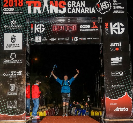
From this point, it was only a measly 10 miles to the end so I left in high spirits and turned up my music to full blast. By this stage in the proceedings, every vestige of my “race plan” had long since been pummeled out of me by the merciless trail. Whilst this is normal for a race of this length, I believe the rocky terrain took an extra toll a bit like being shaken violently for hours on end. Other ultras are perhaps harder in their own way but TGC was definitely the hardest underfoot conditions that I’ve ever experienced. The climb out of Ayagaures was a straightforward affair on a driveable cinder track. On the other side, however, things got more interesting as we descended into the Barranco (dried-up river bed) that would lead us all the way to the finish line. Mile after mile of wobbly stones interspersed with two metre high reeds accompanied us all the way to the outskirts of Maspalomas where the trail started to turn into a giant storm drain that would run all the way to the finish line at the Expomeloneras centre. Despite the ankle issue, I managed to summon up a sprint finish of sorts and was delighted to cross the line in 26 hours and 45 minutes. Thanks for reading!