There are two reasons why I signed up to the 10 Peaks Brecon Beacons this year. Having enrolled for TGC in early 2018, I wanted to gauge my hill strength so that I could focus my winter training in the right areas. As an added bonus, I also wanted to see if I could beat my 2013 time in this race when I was a fresh-faced newcomer to the eccentric world of ultramarathons.
The course
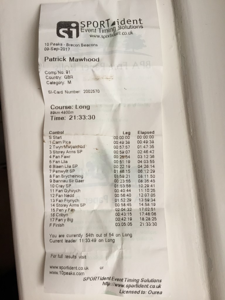
Weighing in at 89 km with 4800m of climbing, the 10 peaks course covers 12 of the highest summits in the Brecon Beacons in South Wales. In my opinion, it’s one of the toughest races in the UK given the average climb per km (54 metres) and the rugged conditions underfoot which include long grass, peat bogs and boulders mixed in with runnable, hard-packed trails. This year the ground was a lot wetter than in 2013 so the going got very muddy, very quickly.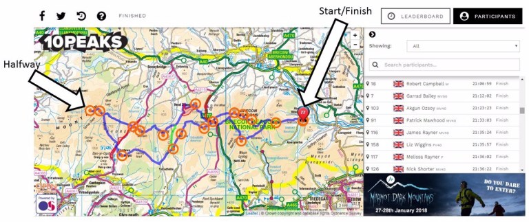
With the race beginning and ending at a Youth Hostel based at the northern end of Talybont reservoir, I opted to camp the night before (and after) owing to the early start at 5 am.

Stage 1: Danywenallt to Storey Arms (18 km, 990m+)
Proceedings kicked off bang-on time and I positioned myself at the back of the field of 100 runners as we crossed the Talybont dam. The route up onto the first climb had changed from 2013 and was much more direct but I was careful to remember it as we weaved around some farm buildings. Last time around, I got lost at the final furlong with the end literally in sight so I resolved not to make the same mistake again. As usual, there was a lot of keenness in the air and much jostling for position on the single track path up to Cairn Pica (573m+) which was already becoming a mud slide. I took a grippy line where the grass met the mud and settled into a reasonably strong march; reaching the first checkpoint in about 7th position which, in retrospect, was overcooking it a tad.
Changing tack to a South-South-East bearing, the course hugged a steep escarpment for a mile or two and afforded us a beautiful sunrise which is always dangerous when you’re trying to cover ground at speed. Your eyes should be on the ground a metre or two ahead of you at all times – not taking in the view and certainly not on a pale sun in the distant horizon. Feeling both fresh and confident, it was therefore only a matter of time before the inevitable happened and I wedged my right ankle between a stone slab and a slippery slice of peat. A gentle twist or two in a divot is common to all my races and usually my ankle just snaps back into place without any drama but this time it twinged (just a little) and from that moment onwards I suppose I eased off a touch for fear of doing some serious damage.
Soon afterwards, the route descended into a valley through some knee-high grass with hidden bog-traps (I’ve made this word up) and a few really gutsy runners started to barrel past me although I reigned some of them in on the second climb up to Twyn Mwyalchod (224m+) having slipped to about 20th position. Hereafter we climbed gradually north west for two miles up to the base of Corn Du where the path headed straight down to the Storey Arms checkpoint and a brace of orange wedges (which was all I could stomach on account of over-eating the night before).
Stage 2: Storey Arms to Penwylt (37 km, 1700m+)
The next climb was a short, sharp affair up to the top of Fan Fawr (308m+) by way of yet more peat swamps. After dibbing in, the rain really started to set in so I donned my trusty, weatherbeaten Berghaus jacket and trotted off down into the sodden valley which stood between me and the next summit at Fan Llia.
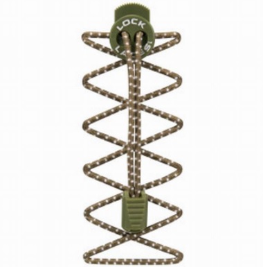
By this time, I had started to frequently lose my shoes in the sense that one of my feet would occasionally dorsiflex away from the ground leaving the shoe wedged in a lonely wallop of mud. After the fifth time or so I realised that there might be a correlation between this and the type of laces I had on my shoes. Having completed a swimrun in Switzerland a couple of months before, I’d forgotten to remove the elasticated lock laces and I started to suspect that this was not only the cause of my lost shoes but was also making my ankles dangerously unstable on the slippery ground owing to the “give” in the elastic. The smart thing to do would have been to stop there and then and swap to traditional laces (I had a couple in my pack that were serving as a binding for my survival bag) but for reasons that now escape me I decided to “sort it out later”.
Around this time I was overtaken by the leader pack in the Short Course variant of the race which had started an hour after us. These guys were absolutely hammering it through the bogs with great bounding leaps – impressive stuff but I wondered if any of them had ever taken a serious tumble. Before long we crested the top of Fan Llia (155m+) in pretty high winds before descending into a lovely, runnable stretch of grass on the leeward side of the mountain. Upon reaching the checkpoint at Blaen Llia I was pleased to see that my appetite had returned with a vengeance as I scoffed five peanut butter sandwiches. They explained that I was 2.5 hours ahead of the cutoff (good news, no pressure) and by now in about 30th position so I set off again onto the relatively flat yet undulating section to the next checkpoint at Penwylt.
Alternating between half a mile of running and half a mile of quick marching, I was making good progress on this stretch until I performed a near perfect replica of my earlier ankle sprain but with a much more painful twist. The nearest person behind me was about 500 metres away and he later asked me what I was shouting about – I swore that loudly because I feared I might not be able to continue but, luckily, the pain quickly subsided and it was only a couple of easy downhill miles to the next checkpoint where I resolved to sort my feet out. Arriving at the farmhouse next to a disused quarry, I thought I’d stumbled into a Ken Loach documentary when I saw all these guys milling around in boiler suits, hard hats and headlamps so I asked them what the craic was. Apparently, this area has one of the largest networks of underground caves and tunnels in the country and these fellas were serious potholers. Fancy that. Now, the race volunteers at this checkpoint were splendid and they plied me with a cup of hot sweet tea which I washed down with four jam sandwiches, a fistful of flapjacks and a wholly unnecessary slice of cake.
Stage 3: Penwylt to Cray (55 km, 2750m+)
Suitably refreshed and properly laced up, I set off down a steep hill towards the foot of the 4 mile slog up to Fan Brycheiniog (597m+). After a while I joined up with Nick who is aiming to do UTMB next year and who completed the Marathon des Sables recently. This section is heavy going and never seems to end but we eventually reached the summit dibber just as some dense fog was setting in. Although technically over halfway in terms of distance, it’s not until you reach the next summit – The Black Mountain – just half a mile away and turn back eastwards that you really feel that you’re on your way home.
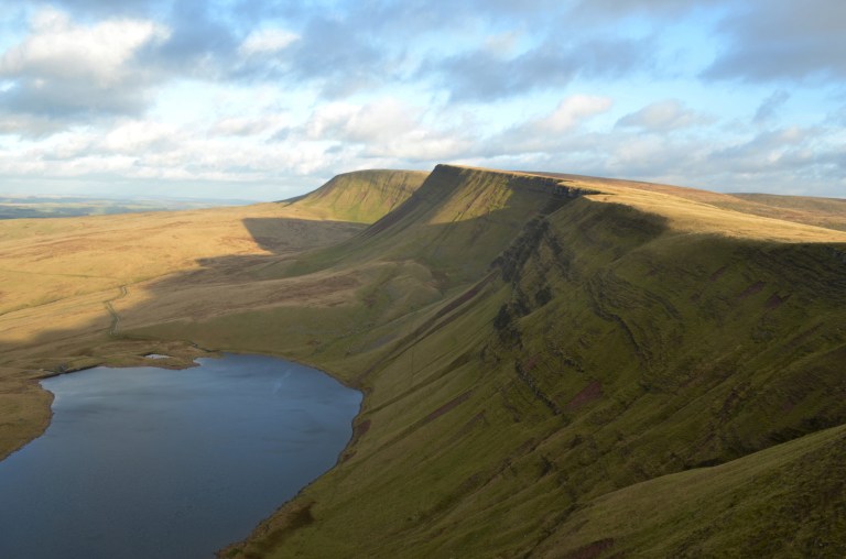
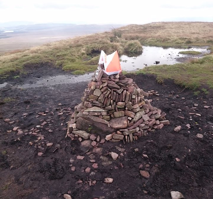
You get down off The Black Mountain via a steep rocky switchback path that provides a lovely view of Llyn y Fan Fawr (the body of water in the picture above). During this stretch I remember babbling on about proper technique or safety or something just before losing my footing and sliding a down a couple of metres on my backside. Hilarious (but you had to be there). Turning to East-by-South-East, the navigation became very simple: we were aiming in a straight line at the base of Fan Gyhirych (a flat, cake-tin shape mountain) about 3 miles away. This stretch was mainly a gradual downhill but with a very boggy hill in the middle which required us to ford a small but fast flowing river (owing to the recent rainfall) at its base. With no discernable paths, it was slow work to wade through the knee-high grass which frequently concealed the sort of bog-traps that make you to stop and tug your foot out with a big squelching sound. Eventually, the bogs gave way to firmer ground and the Cray checkpoint came into view.
Stage 4: Cray to Storey Arms (73 km, 3520m+)
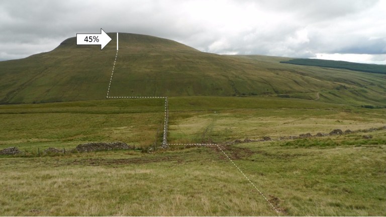
I hate Fan Gyhirych (358m+). OK so it’s not that big, but it does have a horrendously steep (45%!) section just before the summit and once you’re at the top then you have to jump across a peat-moat to reach the checkpoint dibber. With the ground now churned up by the runners ahead of us into the texture of a ski-jump; I opted to veer off the path and climb up through the peat hags using my walking poles on the shortest setting a bit like a pair of pick axes.
They say it is darkest just before the dawn and so the reward for my toil was a sublime cinder track that gracefully ebbed and flowed all the way down to the next climb at Fan Nedd. I had almost forgotten what it felt like to run normally as opposed to flailing around in the undergrowth like a demented banana as had become the norm on this race. The climb up to Fan Nedd (180m+) was straightforward although the summit itself was set back from the main promontory (which itself had a huge cairn) by a few hundred metres. After a steep descent, the route merged with a rocky path which we followed all the way round to the base of Fan Frynych. After reaching the top, the course veers south east to handrail a contour line parallel to the southbound A470 from Brecon and we could start to see the Storey Arms checkpoint a couple of miles ahead. When I did the race in 2013, we were given a voucher for a hamburger from a kebab van that was parked at this checkpoint and I let this gorgeous prospect develop into a deeply-held expectation that I foolishly shared with some other runners who then ostracized me when the only hot food on offer transpired to be a cup-a-soup. Austerity perhaps?
Stage 5: Storey Arms to Danywenallt (89 km, 4800m+)
The last stretch to the finish doesn’t look like much. It’s only 16 km as the crow flies but it includes three summits (one of which is the highest point in the race) and is largely tackled in darkness. With the sun starting to go down, I took the opportunity to put on my headtorch and a warm top before joining up with Nick again for the final push. We opted to take the slightly longer but less steep route up to Pen y Fan (500m+). Once we were about three quarters of the way up, a dense mist set in and despite having done this climb more than twenty times, I took the wrong path over the top of Corn Du rather than around it. From the top of Corn Du, we got into a bit of a pickle trying to work out the correct bearing towards Pen y Fan which was only a few hundred metres away. With a steep escarpment nearby and the temperature dropping rapidly, it was a bad idea to stop moving but an even worse one to take a wrong turn, get lost and tumble off a cliff so we took a few minutes and eventually worked it out.

After descending Pen y Fan we were straight up Cribyn (100m+) and on our way to the last climb up to Fan y Big (120m+). Around this time, the mist cleared into a full moon which made the navigation easier as the course undulated towards the final descent down to Talybont reservoir where we’d set off so many hours before. It was a relief to finally get off the muddy path and onto some tarmac so I celebrated by running the last half mile to cross the finish line in style.